

HELP US PRESERVE AND SHARE YOUR HISTORY

RCAF/CFS ALSASK
44 / C-53
>>>**TOUR DATES AND EVENTS**<<<


| Site #: | C-53 (RCAF) | |
| AC&W #: | 44 Radar Squadron | |
| Callsign: | November, Jade Ring | |
| Construction Dates: | Start: | January, 1961 |
| End: | December, 1962 | |
| Operational Date: | Early 1963 | |
| SAGE Operational: | May 1963 | |
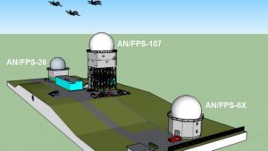
| Radar Equipment: | Search: | FPS-7C, FPS-107 |
| Height: | FPS-26, FPS-507A , FPS-6X | |
| Closure Date: | August, 1987 |
The radar station (site C-53) is located at the junction of provincial highways 7 and 44, on the border of Alberta and Saskatchewan, hence its name. The nearest community was the village of Alsask, which bordered the southern boundary of the 418 acre military facility. Saskatoon was 184 miles to the east, while 225 miles away to the west was Calgary. The area had typical glacial moraine with gentle rolling hills, and was notorious for dust storms, high winds, electric storms and fierce blizzards.
RCAF Station Alsask was conceived in 1959 as part of the CADIN/Pinetree Project. Initial clearing and grading of the land began in the summer of 1961. Construction commenced soon after and was completed in December 1962. On 1 November 1962, RCAF Station Alsask was officially established. The long range radar unit, 44 Radar Squadron, was operational and took over the newly constructed station in early 1963. Equipment at the station included the FPS-107 Search and the FPS-507A, FPS-26 and FPS-6X Height Finder radars. The site was declared SAGE-Operational in May 1963 at which time the entire station was declared operational within the 24th NORAD Region.
The station was later known as a Canadian Forces Station in May 1967. In the fall of 1983, the ROCC concept was introduced to replace SAGE. In August 1984, both ROCCs Canada East and Canada West (Alsask came under Canada West) were declared operational.
Alsask carried on with their assigned duties until they were disbanded on 1 August 1987.
Alsask OPS site was taken over by the Canadian Civil Defence Museum Association/Archives(CCDMA) June 1 of 2018. The CCDMA is restoring the tower to its original state and finally after all these years are allowing tours for the general public.
>>>>>***CFS ALSASK ARCHIVES***<<<<<

***Additional History***
***TOUR DATES AND EVENTS***
***ALSASK TOURIST INFORMATION***
ALSASK
|
Serial |
Description |
Cost |
|
1 |
Clearing, Grubbing & Rough Grading |
$40,000 |
|
2 |
Roads, Walks & Parking Areas & Drainage (includes PMQ roads and walks) |
210,000 |
|
3 |
Fencing |
42,000 |
|
4 |
Sewage Treatment Plant & Collector System (includes PMQ service) |
125,000 |
|
5 |
Water Treatment Plant, Pumping, Storage and Distribution (includes PMQ Service) |
450,000 |
|
6 |
Underground Heating Distribution System |
230,000 |
|
7 |
Electrical Distribution, Street Lighting, Fire Alarming System (includes PMQ service and service to communications facility) |
395,000 |
|
8 |
Gate and Guard House and Two Gate Houses |
25,000 |
|
9 |
Administrative/Hospital Building |
130,000 |
|
10 |
Combined Mess Building |
275,000 |
|
11 |
Combined Quarters Building |
316,000 |
|
12 |
Combined Mobile Equipment/Unit Supply Building |
128,000 |
|
13 |
Combined Construction Engineering/Fire Hall Building |
111,000 |
|
14 |
5-Class School Building |
140,000 |
|
15 |
Combined Chapel Building |
87,000 |
|
16 |
Combined Heating/Power Plant Building |
650,000 |
|
17 |
Mobile Homes, 90 units at $11,600 (including transportation, foundations, and hooking to services) |
1,044,000 |
|
19 |
FPS-26 Height Finder Radar Tower |
300,000 |
|
20 |
FPS-6 Height Finder Tower (foundations only – Technical equipment and tower from US sources) |
20,000 |
|
21 |
FPS-27 Search Radar Tower |
800,000 |
|
22 |
SAGE Annex Building |
195,000 |
|
23 |
Telephone Building |
134,000 |
|
24 |
Ground to Air Transmitter and Receiver Building including Antenna Foundations |
125,000 |
|
25 |
Grading and Landscaping |
94,500 |
|
26 |
Sports Field Facilities |
20,000 |
|
27 |
Fuel Storage & Handling Facilities |
72,000 |
|
|
TOTAL |
$6,158,500 |


HELP US PRESERVE AND SHARE YOUR HISTORY

